Jamaica’s $150 million IBRD CAR Jamaica 2024 parametric World Bank catastrophe bond has been marked down on secondary pricing sheets and this morning the US National Hurricane Center forecast cone shows a major hurricane Melissa landfall as possible.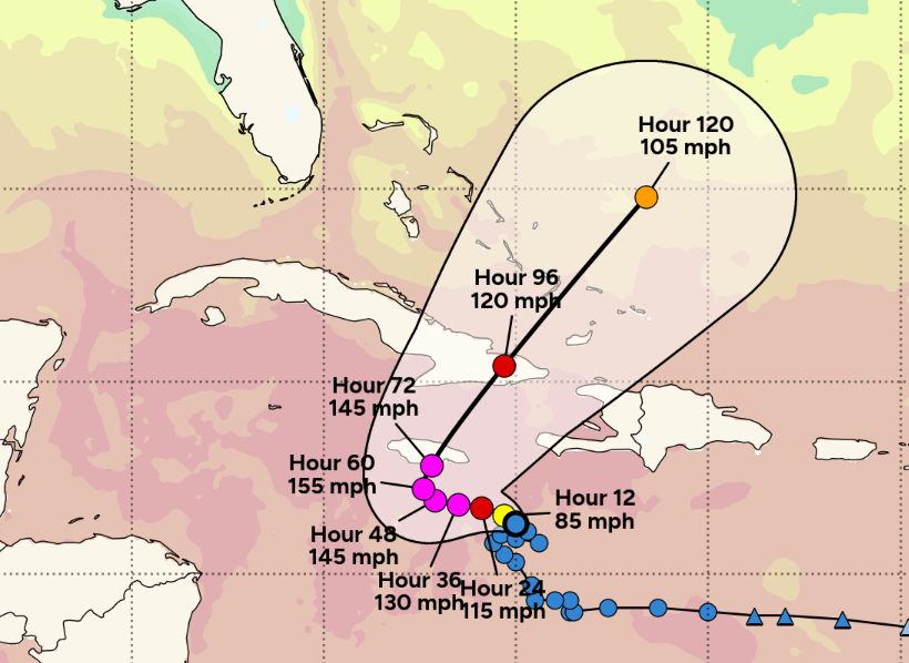
Melissa became a hurricane on Saturday evening our time, an update is at the foot of this article.
It’s important to note that there remains considerable uncertainty and the forecast could change, sparing Jamaica from a major hurricane direct landfall.
The NHC forecast cone currently points to landfall as occurring on Tuesday 28th, with a slow moving Melissa forecast to enter a phase of rapid intensification as it moves slowly towards Jamaica.
The forecast at this time shows hurricane Melissa intensifying rapidly to become a major storm, with wind speeds potentially reaching 155 mph prior to landfall in Jamaica and 145 mph when it gets to the coast, a scenario no one wants to see for the people in its path.
You can see Tomer Burg’s graphic of the NHC forecast cone with the forecast advisory wind speeds below (this image should update over time):
It means there are a number of days left for the steering currents to hopefully shift Melissa away from this major hurricane landfall outcome. For the people of Jamaica we certainly hope that the forecasts become more favourable over time.
But numerous forecast models continue to show a landfall event in Jamaica at major Category 4 or 5 strength, which could be particularly impactful for the country and a severe danger to lives, livelihoods and property there.
The forecasts currently show a scenario that would put Jamaica’s IBRD CAR Jamaica 2024 parametric World Bank catastrophe bond at meaningful risk of being triggered, with a number of models showing a deep enough pressure to potentially activate the cat bond’s payout mechanism.
The NHC’s forecast as of Saturday morning suggests a major hurricane Melissa landfall with sustained winds of as high as 155 mph, a scenario that would suggest Melissa’s minimum central pressure could fall to levels low enough to trigger the World Bank facilitated catastrophe bond, should it pass through one of the parametric boxes at a pressure low enough to activate a payout.
As we’ve explained previously, it is central pressure and location of a hurricane that matters for the cat bond, with Jamaica and the surrounding sea broken into parametric boxes for the IBRD cat bond’s trigger (more details on that can be seen in one of our articles related to 2024’s hurricane Beryl).
We understand that the lowest payout threshold possible is for a 30% triggering of the cat bond note principal, while a more intense storm can cause a full payout just for entering a single box. Parametric boxes can also be additive, in that if a storm passes through more than one the payout for each can get added together, under certain circumstances.
Given the number of days left before the currently forecast landfall, there remains a good deal of uncertainty and the path Melissa takes as it intensifies and meanders through the Caribbean could be critical in whether or where a direct landfall takes place.
But whether it directly passes over Jamaica or not, hurricane Melissa looks set to bring significant impacts to Jamaica, with some days of tropical storm and hurricane wind speeds and well over 20 inches of rainfall deemed likely now, a dangerous scenario even if landfall does not occur.
Given the evident risk to the Jamaica catastrophe bond, we’re told the notes have been marked down in a number of the cat bond market’s secondary pricing sheets, with bids now ranging from as low as 60 cents on the dollar, indicating market uncertainty as a hurricane approaches. However, given the evident threat of a triggering event, if the current forecast scenario plays out, it seems unlikely any live cat trading would be seen unless at more distressed pricing levels.
You can read what a number of cat bond fund managers said about Melissa and the Jamaica cat bond in our article from Thursday morning that we updated on Friday here.
If the current NHC forecast were to play out we assume Jamaica’s parametric disaster insurance arrangements would also face a high risk of being triggered and these are structured in such a way as to activate and payout before the cat bond, with the cat bond sitting at the highest, more remote layers in the country’s sophisticated disaster risk financing tower.
What will become major hurricane Melissa also poses a significant threat to eastern Cuba as well, where a landfall is also currently forecast at major wind speeds.
For the people of Jamaica and Cuba we hope the forecast shifts with time over the next few days, to minimise the chances of what could be a particularly devastating and dangerous scenario for these regions.
A faster forward pace could reduce the time available to intensify, or a more westward track as some models were still showing yesterday could take Melissa around Jamaica. But even the GFS model, which has been an outlier in taking hurricane Melissa north earlier and to the east of Jamaica, is now moving closer to the country with each model run.
We will likely update this article over the weekend as the situation develops.
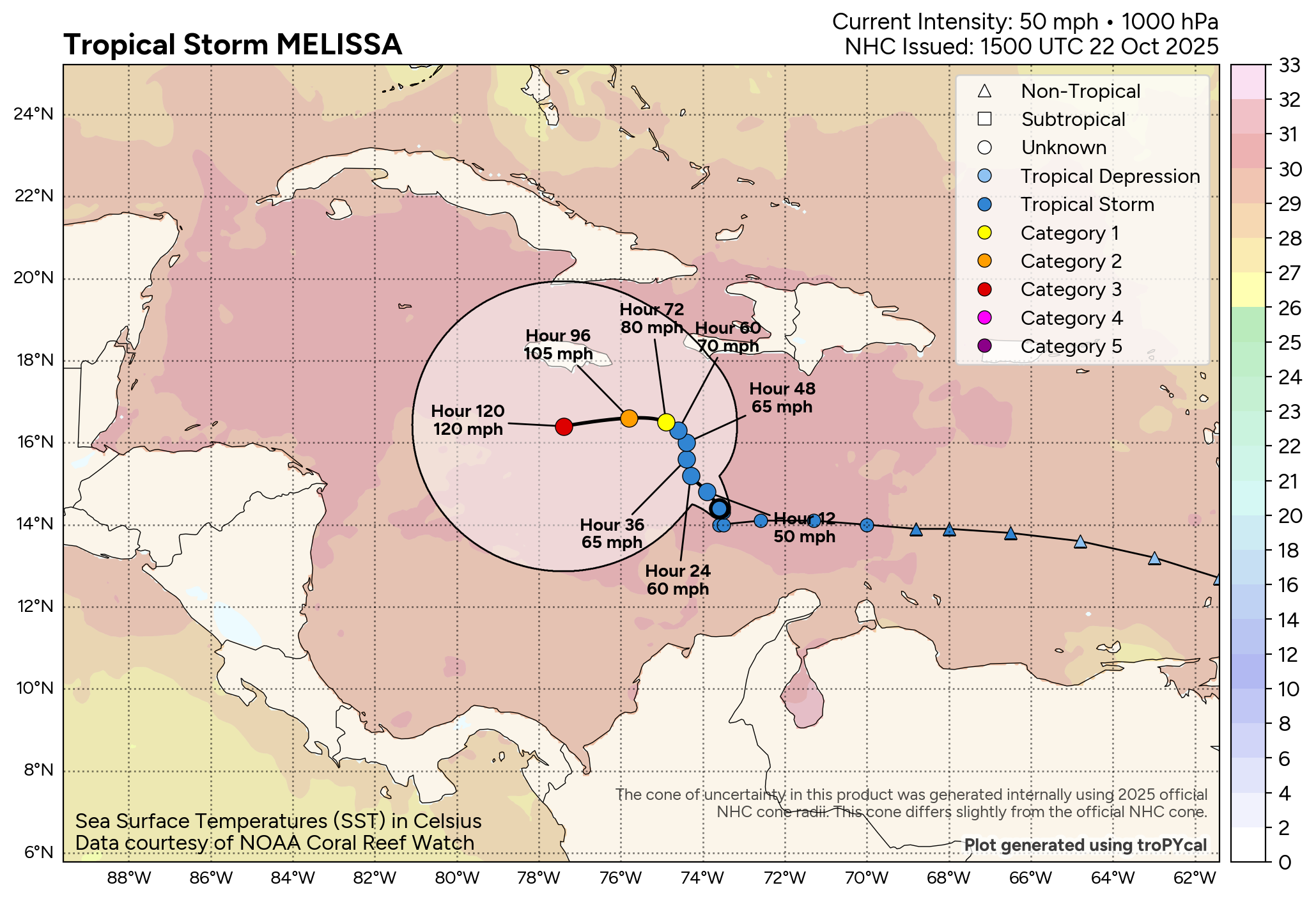
Update – Sat 25th October, 19:00 BST: Melissa has now become a hurricane with 75 mph sustained winds.The forecast cone has not changed significantly, with a major hurricane landfall still indicated for Jamaica.
The NHC stated, “Maximum sustained winds have increased to near 75 mph (120 km/h) with higher gusts. Rapid intensification is forecast to occur over the next couple of days and Melissa is forecast to become a major hurricane by Sunday.”
The NHC also said, “A turn to the north and northeast is forecast on Monday and Tuesday. On the forecast track, the center of Melissa is expected to move near or over Jamaica during the weekend and early next week, and it could be near or over eastern Cuba by the middle of next week.”
You can track this and every Atlantic hurricane season development using the tracking map and information on our dedicated page.
